
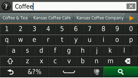
jual gps garmin etrex 10
jual gps garmin
Add to Cart More Info
 CALL
CALL
Physical & Performance |
|
| Unit dimensions, WxHxD | 11.5" x 7.4" x 2.9" (29.3 x 18.8 x 7.4 cm) |
| Display size, WxH | 6.4" x 4.8"; 8.0" diagonal (16.2 x 12.1 cm; 20.3 cm diagonal) |
| Display resolution, WxH | 800 x 600 pixels |
| Display type | SVGA display |
| Weight | 3.5 lbs (1.6 kg) |
| Waterproof | Yes (IPX7) |
| Receiver | 10 Hz high-sensitivity |
| Antenna | with external connection |
| Mounting options | Bail, flat or flush |
| Power consumption | Max power usage at 10 Vdc: 14 W Typical current draw at 12 Vdc: 1.1 A Max current draw at 12 Vdc: 3.2 A |
Maps & Memory |
|
| Preloaded maps | None |
| Accepts data cards | 2 SD™ cards |
| Waypoints | 12,000 |
| Routes | 200 |
| Track log | 25,000 points; 100 saved tracks |
Features & Benefits |
|
| Garmin Radar compatible | Yes |
| Garmin Sonar compatible | Yes (built-in) and GCV™ black box compatible |
| NMEA 2000® compatible | No |
| NMEA 0183 compatible | Yes |
| Garmin Marine Network™ compatible | Yes (limited capabilities) |
| Garmin SmartMode compatible (customizable monitor presets) | No |
| Supports AIS (tracks target ships position) | Yes |
| Supports DSC (displays position data from DSC-capable VHF radio) | Yes |
| Tide tables | Yes |
| Garmin Meteor Audio System compatible | No |
| Supports Fusion Lync compatible marine radios | No |
| GSD™ Black Box sonar support | No |
| GCV™ Black Box sonar support | Yes |
| SiriusXM™ Weather & Radio compatible | No |
| BlueChart® Mobile (planning) compatible | No |
| Garmin Helm compatible | No |
| GRID™ (Garmin Remote Input Device) compatible | No |
| Wireless remote compatible | No |
| Wireless mouse compatible | No |
Sonar Features & Specifications |
|
| Dual-frequency (50/200 kHz) sonar capable | Yes |
| Dual-beam (77/200 kHz) sonar capable | Yes |
| Frequencies supported | 50/77/200 kHz, CHIRP (low, medium, high), DownVü |
| Transmit power | 1 kW traditional; 600 W CHIRP |
| CHIRP sonar technology | Yes (Built-in) |
| DownVü™ | Yes with CHIRP (built-in) |
| SideVü™ | Yes (with GCV™ black box, sold separately) |
| Voltage range | 10-32 Vdc input |
| Maximum depth | 1,750 ft @ 50 kHz, saltwater, Garmin dual freq transducer @ 500 W 2,700 ft @ 50 kHz, saltwater, Airmar B260 transducer @ 1000 W (depth capacity is dependent on water bottom type and other water conditions) |
| Bottom lock (shows return from the bottom up) | Yes |
| Water temperature log and graph | Yes |
| Sonar recording | Yes |
| Sonar history rewind | No |
Connections |
|
| NMEA 0183 input ports | 2 |
| NMEA 0183 output ports | 2 |
| Video input ports | None |
| Video output ports | None |
| Wireless connectivity | No |
| Garmin Marine Network™ ports | 1 |
 CALL
CALL
Physical & Performance |
|
| Display resolution, WxH | 480 x 320 pixels |
| Display type | FSTN 4-level monochrome |
| Water rating | IPX7 |
| Antenna | Internal with external connection |
| NMEA 0183 compatible | |
| Garmin Marine Network™ ports | Auncun |
Maps & Memory |
|
| Preloaded maps | Auncun |
| Accepts data cards | Non |
| Waypoints | 3,000 |
| Routes | 50 |
| Track log | 10,000 trackpoints |
Chartplotter Features |
|
| Garmin Sonar compatible | Non |
| BlueChart® Mobile (planning) compatible | Non |
| Garmin Helm compatible | Non |
Connections |
|
| NMEA 0183 input ports | 1 |
| NMEA 0183 output ports | 1 |
| Video input ports | Auncun |
| Video output ports | Auncun |
| Wireless connectivity | Non |
 CALL
CALL |
 |
| Dual Range Operation | Dynamic Auto Gain and Sea Filter |
 |
 |
| xHD performance in a dome | Radar Overlay |
Physical & Performance |
|
| Unit dimensions, WxHxD | 11.2”x6.7”x2.9”(28.5x17.2x93 cm) |
| Display size, WxH | 6.8”x5.1”, 8.4” |
| Display resolution, WxH | 800 x 600 pixels |
| Display type | SVGA display |
| Weight | 3.1lbs(1.4kg) |
| Waterproof | (IPX7) |
| GPS Receiver | 1 Hz sensitivity |
| GPS Antenna | With external connection (BNC) |
| Mounting options | Bail, flush |
| Power Supply Range | 11-32 VDC |
| Power consumption | Max power usage at 10 Vdc: 14 W Typical current draw at 12 Vdc: 1.1 A Max current draw at 12 Vdc: 3.2 A |
Maps & Memory |
|
| Preloaded maps | None |
| Accepts data cards | 1 SD™ card |
| Waypoints | 12,000 |
| Routes | 200 (max 250 waypints per route) |
| Track log | 25,000 points; 100 saved tracks (max 2500 marks per tracks) |
Features & Benefits |
|
| Garmin Radar compatible | |
| Garmin Sonar compatible | |
| NMEA 2000® compatible | |
| NMEA 0183 compatible | |
| Garmin Marine Network™ compatible | (limit capabilities) |
| Garmin SmartMode compatible (customizable monitor presets) | |
| Supports AIS (Automatic Identification System) | (NMEA0183) |
| Supports DSC (displays position data from DSC-capable VHF radio) | (NMEA0183) |
| Tide tables | |
| GSD™ Black Box sonar support | |
| GCV™ Black Box sonar support | |
| BlueChart® Mobile (planning) compatible | |
| Garmin Helm compatible | |
| GRID™ (Garmin Remote Input Device) compatible | |
| Wireless remote compatible | |
| Wireless mouse compatible | |
Connections |
|
| NMEA 0183 input ports | 2 |
| NMEA 0183 output ports | 2 |
| Video input ports | None |
| Video output ports | (D-Sub) |
| Wireless connectivity | |
| Garmin Marine Network™ ports | 1 (RJ45) |
 CALL
CALL
Fisik & Kinerja |
|
| Dimensi fisik | 6,6"L x 3,7"T x 0,8"T (16,8 x 9,4 x 2,1 cm) |
| Ukuran tampilan, LxT | 5,4”L x 2.8”T (13,6 x 7,2 cm); 6,1” diag (15,4 cm) |
| Resolusi tampilan, LxT | 800 x 480 piksel |
| Jenis tampilan | TFT warna WVGA dengan lampu latar putih |
| Berat | 244g |
| Baterai | litium-ion yang dapat diisi ulang |
| Masa pakai baterai | hingga 1 hour |
| Colokan headphone/saluran keluar audio | Tidak |
| Penerima bersensitivitas tinggi | Ya |
| Penilaian air | Tidak |
Peta & Memori |
|
| Peta jalan yang telah dimuat | Ya |
| Termasuk pembaruan peta lifetime | Ya |
| Garansi nüMaps | Ya |
| Pandangan dataran 3-D | Tidak |
| Pandangan bangunan dan landmark 3-D | Tidak |
| Memori bawaan | NAND flash 4G |
| Menerima kartu data | Kartu microSD™ (tidak disertakan) |
| Titik arah/favorit/lokasi | 1000 |
Fitur & Kelebihan |
|
| Fitur yang Menghemat Waktu & Uang | |
| Perintah Suara (misalnya "Belok kanan dalam jarak 500 kaki") | Ya (Speaker internal) |
| Menyebutkan nama jalan (misalnya "Belok kanan DI ELM STREET dalam jarak 500 kaki") | Ya |
| Navigasi yang diaktifkan suara (mengoperasikan perangkat menggunakan perintah yang diucapkan) | Tidak |
| Kompatibel dengan lalu-lintas (rute di sekitar lalu lintas dengan penerima dan berlangganan) | Tidak |
| Bantuan lajur (pemandu ke lajur yang tepat untuk navigasi) | Ya |
| Tampilan simpangan (menampilkan rambu simpangan) | Ya |
| Sortir beberapa tujuan secara otomatis (menyediakan rute yang paling langsung) | Ya |
| Hindaran rute (menghindari jalan utama, tol, dsb.) | Ya |
| Fitur Navigasi Aman | |
| Teknologi nirkabel Bluetooth® | Tidak |
| Indikator batas kecepatan (menampilkan batas kecepatan untuk sebagian besar jalan besar di Indonesia) | Ya |
| Di mana saya? (menemukan rumah sakit, kantor polisi & pom bensin terdekat, alamat & persimpangan terdekat) | Ya |
| Navigasi pejalan kaki yang telah disempurnakan (memandu Anda saat berjalan kaki di seputar kota) | Tidak |
| Navigasi foto (navigasi ke foto yang ditandai) | Tidak |
| Melihat titik perhatian mendatang di sepanjang rute | Ya |
| POI kustom (kemampuan untuk menambah titik perhatian tambahan) | Ya |
| Garmin Lock™ (fitur anti-pencurian) | Tidak |
| Fitur yang Dapat Disesuaikan | |
| Kompatibel dengan kendaraan Garmin Garage™ (mengunduh ikon berbentuk kendaraan ke perangkat Anda) | Ya |
| Kompatibel dengan suara Garmin Garage™ (mengunduh suara kustom ke perangkat Anda) | Ya |
| Pemutar MP3 | Tidak |
| Pemutar buku audio | Tidak |
Spesifikasi Tambahan |
|
| Perencana Perjalanan | Ya |
| Log Perjalanan | Ya |
| Perangkat penyimpanan massal USB ini kompatibel dengan Windows® XP atau versi yang lebih tinggi. | |
 CALL
CALL
Tampilan & Performa: |
|
|
Dimensi unit, L x P x T: |
4.8"L x 2.9"P x .35"T (12.2 x 7.5 x .89 cm) |
|
Ukuran layar, L x P: |
3.7"L x 2.2"P (9.4 x 5.6 cm); 4.3" diag (10.9 cm) |
|
Resolusi layar, L x P: |
800 x 480 piksel |
|
Jenis layar: |
kaca, orientasi-ganda, TFT WVGA berwarna dengan lampu latar putih |
|
Berat: |
113.4 gr |
|
Battery: |
lithium-ion yang dapat diisi ulang |
|
Masa pakai baterai: |
hingga 3 jam |
|
Kedap air: |
tidak |
|
Unit penerima dengan sensitivitas tinggi: |
ya |
Peta & Memori: |
|
|
Peta basis: |
ya |
|
Peta jalan yang telah terinstal: |
ya |
|
Pembaruan peta Lifetime: |
ya |
|
Kemampuan untuk menambahkan peta: |
ya |
|
Memori internal: |
Flash NAND 4G |
|
Menerima kartu data: |
Kartu microSD™ (tidak disertakan) |
|
Titik acuan/favorit/lokasi: |
1000 |
|
Route: |
100 |
Fitur: |
|
|
Perintah suara (misalnya "Turn right in 500 ft." (Belok kanan pada jarak 500 kaki)): |
ya (speaker internal) |
|
Mengucapkan nama jalan (misalnya "Turn right ON ELM STREET in 500 ft." (Belok kanan DI ELM STREET pada jarak 500 kaki)): |
ya (hanya bahasa tertentu) |
|
Navigasi yang diaktifkan melalui suara (operasikan perangkat dengan perintah suara): |
tidak |
|
Info jalur (memandu Anda ke jalur yang sesuai untuk navigasi): rintah suara): |
ya (dengan tampilan persimpangan jalan) |
|
myTrends™ (memprediksi rute berdasarkan aktivitas navigasi pengguna): |
ya |
|
Tampilan gedung 3-D (menampilkan gedung dalam 3-D): |
ya |
|
Pengurutan beberapa tujuan secara otomatis (menyediakan rute paling pendek): |
ya |
|
Perubahan rute otomatis (penghitungan ulang cepat di luar rute dan rute memutar): |
ya |
|
Pilihan konfigurasi rute (waktu yang lebih cepat, jarak yang lebih pendek, off road): |
ya |
|
Penghindaran rute (hindari jalan raya, tol, dsb.): |
ya |
|
Teknologi nirkabel Bluetooth®: |
ya |
|
Indikator batas kecepatan (menampilkan batas kecepatan untuk sebagian besar jalan raya di Indonesia): |
ya |
|
Where Am I? (Di Mana Saya?) (mencari rumah sakit, kantor polisi, SPBU, alamat, dan persimpangan jalan terdekat): |
ya |
|
Garmin Locate™ (menandai posisi bila dilepas dari pemasangan di kaca depan): |
ya |
|
ecoRoute™: |
ya |
|
Keyboard Qwerty atau ABC (pilih tata letak keyboard): |
ya |
|
POI kustom (kemampuan untuk menambahkan tempat tujuan lain): |
ya |
|
Garmin Garage™ yang kompatibel dengan kendaraan (download ikon berbentuk mobil ke perangkat): |
ya |
|
Garmin Garage™ yang kompatibel dengan suara (download suara kustom ke perangkat): |
ya |
|
Navigasi foto (navigasikan ke foto berpenanda geografis): |
ya |
|
Jam di seluruh dunia, pengkonversi mata uang & satuan, kalkulator: |
ya |
|
Penampil gambar: kulator: |
ya |
|
Pemutar MP3: |
ya |
|
Pemutar Video: |
ya (hanya format .wmv) |
|
Pemancar FM: |
tidak |
|
Soket headphone/jalur keluar audio: |
ya |
|
Garmin Lock™ (fitur antipencurian): |
ya |
|
Layar sentuh: |
ya (multi-sentuh) |
|
Dapat digunakan di sepeda motor: |
tidak |
|
Dapat digunakan di truk: |
tidak |
|
Dapat digunakan untuk pencarian cache geografis: |
tidak |
|
Dapat digunakan di laut: |
tidak |
|
Tambahan: |
Perangkat penyimpanan massal USB ini kompatibel dengan Windows® XP atau yang lebih baru. |
 CALL
CALLTampilan & Performa: |
|
| Dimensi unit, L x P x T: | 4,8" L x 2,9" P x 0,6" T (12,1 x 7,6 x 1,5 cm) |
| Ukuran layar, L x P: | 3,81" L x 2,25" P (9,7 x 5,7 cm); 4,3" diag (10,9 cm) |
| Resolusi layar, L x P: | 480 x 272 piksel |
| Jenis layar: | TFT WQVGA berwarna dengan lampu latar putih |
| Berat: | 142 gr |
| Baterai: | lithium-ion yang dapat diisi ulang |
| Masa pakai baterai: | hingga 2.5 jam |
| Kedap air: | tidak |
| Unit penerima dengan sensitivitas tinggi: | ya |
Peta & Memori: |
|
| Peta basis: | ya |
| Peta jalan yang telah terinstal: | ya |
| Pembaruan peta Lifetime: | ya |
| Kemampuan untuk menambahkan peta: | ya |
| Memori internal: | Flash NAND 2G |
| Menerima kartu data: | Kartu microSD™ (tidak disertakan) |
| Titik acuan/favorit/lokasi: | 1000 |
| Rute: | 100 |
Fitur: |
|
| Perintah suara (misalnya "Turn right in 500 ft." (Belok kanan pada jarak 500 kaki)): 9 cm) | ya (speaker internal) |
| Mengucapkan nama jalan (misalnya "Turn right ON ELM STREET in 500 ft." (Belok kanan DI ELM STREET pada jarak 500 kaki)): k 500 kaki)): | ya (hanya bahasa tertentu) |
| Navigasi yang diaktifkan melalui suara (operasikan perangkat dengan perintah suara): | tidak |
| Info jalur (memandu Anda ke jalur yang sesuai untuk navigasi): | ya (dengan tampilan persimpangan jalan) |
| myTrends™ (memprediksi rute berdasarkan aktivitas navigasi pengguna): | ya |
| Tampilan gedung 3-D (menampilkan gedung dalam 3-D): | tidak |
| Pengurutan beberapa tujuan secara otomatis (menyediakan rute paling pendek): | ya |
| Perubahan rute otomatis (penghitungan ulang cepat di luar rute dan rute memutar): | ya |
| Pilihan konfigurasi rute (waktu yang lebih cepat, jarak yang lebih pendek, off road): | ya |
| Penghindaran rute (hindari jalan raya, tol, dsb.): | ya |
| Teknologi nirkabel Bluetooth®: | ya |
| Indikator batas kecepatan (menampilkan batas kecepatan untuk sebagian besar jalan raya di Indonesia): | ya |
| Where Am I? (Di Mana Saya?) (mencari rumah sakit, kantor polisi, SPBU, alamat, dan persimpangan jalan terdekat): | ya |
| Garmin Locate™ (menandai posisi bila dilepas dari pemasangan di kaca depan): | ya |
| ecoRoute™ : | ya |
| Keyboard Qwerty atau ABC (pilih tata letak keyboard): | ya |
| POI kustom (kemampuan untuk menambahkan tempat tujuan lain): | ya |
| Garmin Garage™ yang kompatibel dengan kendaraan (download ikon berbentuk mobil ke perangkat): | ya |
| Garmin Garage™ yang kompatibel dengan suara (download suara kustom ke perangkat): | ya |
| Navigasi foto (navigasikan ke foto berpenanda geografis): | ya |
| Jam di seluruh dunia, pengkonversi mata uang & satuan, kalkulator: | ya |
| Penampil gambar: | ya |
| Pemutar MP3: | tidak |
| Pemutar buku audio: | tidak |
| Pemancar FM: | tidak |
| Soket headphone/jalur keluar audio: | tidak |
| Garmin Lock™ (fitur antipencurian): | yes |
| Layar sentuh: | yes |
| Tambahan: | Perangkat penyimpanan massal USB ini kompatibel dengan Windows® XP atau yang lebih baru. |
 CALL
CALL
Physical & Performance: |
|
|
Unit dimensions, WxHxD: |
5.4"W x 3.3"H x .6"D (13.7 x 8.3 x 1.5 cm) |
|
Display size, WxH: |
4.4"W x 2.5"H (11.1 x 6.3 cm); 5.0" diag (12.7 cm) |
|
Display resolution, WxH: |
480 x 272 pixels |
|
Display type: |
WQVGA color TFT with white backlight |
|
Weight: |
192 g |
|
Battery: |
rechargeable lithium-ion |
|
Battery life: |
up to 2 hours |
|
Waterproof: |
no |
|
High-sensitivity receiver: |
yes |
Maps & Memory: |
|
|
Basemap: |
yes |
|
Preloaded street maps: |
yes |
|
Includes lifetime map updates: |
yes |
|
Ability to add maps: |
yes |
|
Built-in memory: |
2G NAND flash |
|
Accepts data cards: |
microSD™ card |
|
Waypoints/favorites/locations: |
1000 |
|
Routes: |
100 |
Features: |
|
|
Voice prompts (e.g. "Turn right in 500 ft."): |
yes (internal speaker) |
|
Speaks street names (e.g. "Turn right ON ELM STREET in 500 ft."): |
yes (English only) |
|
Voice-activated navigation (operate device with spoken commands): |
no |
|
Lane info (guides you to the proper lane for navigation): |
yes (with junction view) |
|
myTrends™ (predicts routes based on user's navigation behavior): |
yes |
|
3-D building view (displays buildings in 3-D): |
no |
|
Auto sort multiple destinations (provides most direct route): |
yes |
|
Auto re-route (fast off-route and detour recalculation): |
yes |
|
Choice of route setup (faster time, shorter distance, off road): |
yes |
|
Route avoidance (avoid highways, tolls etc.): |
yes |
|
Bluetooth® wireless technology: |
yes |
|
Speed limit indicator (displays speed limit for most major roads): |
yes |
|
Where Am I? (find closest hospitals, police & gas stations, nearest address & intersection): |
yes |
|
Garmin Locate™ (marks position when removed from windshield mount): |
yes |
|
ecoRoute™ (eco-friendly suggestion) : |
yes |
|
Qwerty or ABC keyboard (choose keyboard layout): |
yes |
|
Custom POIs (ability to add additional points of interest): |
yes |
|
Garmin Garage™ vehicles compatible (download car-shaped icons to your device): |
yes |
|
Garmin Garage™ voices compatible (download custom voices to your device): |
yes |
|
Photo navigation (navigate to geotagged photos): |
yes |
|
World travel clock, currency & unit converter, calculator: |
yes |
|
Picture viewer: |
yes |
|
Analogue television: |
yes |
|
Garmin Lock™ (anti-theft feature): |
yes |
|
Touchscreen: |
yes |
|
Additional: |
This USB mass storage device is compatible with Windows® XP or newer |
 CALL
CALL
Tampilan & Performa: |
|
| Dimensi unit, L x P x T: | 5,4" L x 3,4" T x 0,5" P (13,8 cm x 8,7 cm x 1,3 cm) |
| Ukuran layar, L x P: | 4,4" L x 2,5" T(11,1 x 6,3 cm); 5" diagonal (12,7 cm) |
| Resolusi layar, L x P: | 800 x 480 piksel |
| Jenis layar: | multi sentuh, kaca, orientasi ganda, TFT warna WVGA dengan latar belakang putih |
| Berat: | 210 g |
| Baterai: | lithium-ion yang dapat diisi ulang |
| Masa pakai baterai: | hingga 2 jam |
| Video masuk: | ya (Hingga 800x400 piksel) |
| Audio keluar: | ya |
| Unit penerima dengan sensitivitas tinggi: | ya |
| Kedap air: | tidak |
Peta & Memori: |
|
| Peta jalAan standar: | ya |
| Termasuk pembaruan peta seumur hidup: | ya |
| Garansi nüMaps: | ya |
| Tampilan dataran 3-D: | ya |
| Tampilan gedung dan bangunan dalam 3-D: | ya |
| Memori internal: | Flash 4G NAND |
| Menerima kartu data: | kartu microSD™ (tidak disertakan) |
| Titik acuan/favorit/lokasi: | 1000 |
| Rute: | 100 |
Fitur dan Manfaat
|
|
| Perintah suara (misalnya "Turn right in 500 ft." (Belok kanan pada jarak 500 kaki)): | ya (spiker dan dudukan internal) |
| Mengucapkan nama jalan (misalnya "Turn right ON ELM STREET in 500 ft." (Belok kanan DI ELM STREET pada jarak 500 kaki)): | ya |
| Navigasi yang diaktifkan melalui suara (operasikan perangkat dengan perintah suara): | ya |
| Kompatibel dengan info lalu lintas (lalu lintas di sekitar rute dengan unit penerima dan langganan): | tidak |
| Info jalur (memandu Anda ke jalur yang sesuai untuk navigasi): rintah suara): | ya |
| Tampilan persimpangan (menampilkan rambu persimpangan): | ya |
nuvi 3560LM SG/MY | Di Perjalanan | Produk | Garmin Indonesia |
|
| myTrends™ (memprediksikan rute Anda): | ya |
| ecoRoute™ (saran ramah lingkungan): | ya |
| Pengurutan beberapa tujuan secara otomatis (menyediakan rute terdekat): | ya |
| Penghindaran rute (hindari jalan raya, tol, dsb.): | ya |
| Smartphone Link (menerima informasi perjalanan): | ya (ponsel Android) |
Menavigasi secara aman dan mudah. |
|
| Teknologi nirkabel Bluetooth®: | ya |
| Indikator batas kecepatan (menampilkan batas kecepatan untuk sebagian besar jalan utama): | ya |
| Fitur Where Am I? (Di Mana Saya?) (mencari rumah sakit, kantor polisi, SPBU, alamat, dan persimpangan jalan terdekat): | ya |
| Garmin Locate™ (menandai posisi bila dilepas dari dudukan di kaca depan): | ya |
| Kompas | ya |
| Navigasi foto (menavigasi ke foto berpenanda geografis): | ya |
| Mode Jalan Raya: | ya |
| Lokasi Tujuan kustom (dapat ditambahkan lokasi tujuan lain): | ya |
| Jam dunia, pengkonversi mata uang & satuan, kalkulator: | ya |
| Keyboard Qwerty atau ABC (pilih tata letak keyboard): | ya |
| Jam alarm: | ya |
Nikmati perjalanan dan ubah sesuai keinginan Anda. |
|
| Garmin Garage™ yang kompatibel dengan kendaraan (download ikon bentuk mobil ke perangkat Anda): | ya |
| Garmin Garage™ kompatibel dengan suara (download suara kustom ke perangkat Anda): | ya |
| Penampil gambar: | ya |
| Pemutar MP3: | ya |
| Pemutar video: | ya (WMV) |
 CALL
CALLPhysical & Performance |
|
| Unit dimensions, WxHxD | 5.12"W x 3.7"H x 1.18"D (13.0 x 9.4 x 3.0 cm) |
| Display size, WxH | 3.7"W x 2.2"H (9.4 x 5.6 cm); 4.3" diag (10.9 cm) |
| Display resolution, WxH | 480 x 272 pixels, 480 x 272 pixels |
| Display type | WQVGA color TFT with white backlight |
| Weight | 9.5 ounces (270 g) |
| Battery | rechargeable lithium-ion |
| Battery life | up to 7 hours, up to 7 hours |
| Headphone jack/audio line-out | Yes |
| High-sensitivity receiver | Yes |
| Waterproof | Yes (IPX7) |
Maps & Memory |
|
| Preloaded street maps | Yes |
| Includes lifetime map updates | Yes |
| nüMaps Guarantee | yes |
| 3-D terrain view | No |
| 3-D buildings and landmarks view | No |
| Built-in memory | internal solid state |
| Accepts data cards | microSD™ card (not included) |
| Waypoints/favorites/locations | 1000 |
Features & Benefits |
|
| Features That Save Time & Money | |
| Voice prompts (e.g. "Turn right in 500 ft.") | Yes (Internal speaker) |
| Speaks street names (e.g. "Turn right ON ELM STREET in 500 ft.") | Yes |
| Voice-activated navigation (operate device with spoken commands) | No |
| Traffic compatible (routes around traffic with a receiver and subscription) | Yes (in automotive mount) |
| Lifetime traffic updates (receive free lifetime traffic updates) | No |
| Lane assist (guides to proper lane for navigation) | Yes |
| Junction view (displays junction signs) | Yes |
| myTrends™ (predicts your routes) | No |
| trafficTrends™ (calculates routes based on predicted traffic flow) | Yes |
| Auto sort multiple destinations (provides most direct route) | Yes |
| Route avoidance (avoid highways, tolls etc.) | Yes |
| XM® compatible for U.S | No |
| Safe Navigation Features | |
| Bluetooth® wireless technology | Yes |
| Speed limit indicator (displays speed limit for most major roads in the U.S. and Europe) | Yes |
| Where Am I? (find closest hospitals, police & gas stations, nearest address & intersection) | Yes |
| Enhanced pedestrian navigation (guides you as you walk around town) | no |
| Photo navigation (navigate to geotagged photos) | No |
| View upcoming points of interest along route | Yes |
| Custom POIs (ability to add additional points of interest) | Yes |
| Garmin Lock™ (anti-theft feature) | No |
| Customizable Features | |
| Garmin Garage™ vehicles compatible (download car-shaped icons to your device) | Yes |
| Garmin Garage™ voices compatible (download custom voices to your device) | Yes |
| MP3 player | No |
| Audio book player | No |
Additional Specs |
|
| Trip Planner: yes Trip Log: yes Tire pressure monitor system: yes; individual sensors sold separately Curvy Roads routing: yes Power supplied to device power cable should be capable of up 12 V (typical) and up to 1 A. zūmo device power consumption is 5 V; 2 A. This USB device is compatible with Windows® XP or newer and Mac® OS X 10.4 or later. |
 CALL
CALL
Physical & Performance |
|
| Physical dimensions | 5.5″W x 3.4″H x 0.8″D (13.9 x 8.6 x 2.0 cm) |
| Display size, WxH | 4.4″W x 2.5″H (11.1 x 6.3 cm); 5.0″ diag (12.7 cm) |
| Display resolution, WxH | 480 x 272 pixels |
| Display type | WQVGA color TFT with white backlight |
| Weight | 6.4 oz (180.1 g) |
| Battery | rechargeable lithium-ion |
| Battery life | up to 2 hours |
| High-sensitivity receiver | YES |
Maps & Memory |
|
| Preloaded street maps | YES |
| Includes lifetime map updates | YES |
| nüMaps Guarantee | YES |
| Built-in memory | internal solid state |
| Accepts data cards | microSD™ card (not included) |
| Custom POIs (ability to add additional points of interest) | YES |
| Waypoints/favorites/locations | 1000 |
Navigation Features |
|
| Speaks street names (e.g. “Turn right ON ELM STREET in 500 ft.”) | YES |
| Lane assist (guides to proper lane for navigation) | YES |
| Junction view (displays junction signs) | YES |
| Route avoidance (avoid highways, tolls etc.) | YES |
| Speed limit indicator (displays speed limit for most major roads in the U.S. and Europe) | YES |
| View upcoming points of interest along route | YES |
Additional |
|
| Additional |
|
 CALL
CALLPhysical & Performance |
|
| Physical dimensions | 2.4" x 4.5" x 1.3" (6.1 x 11.4 x 3.3 cm) |
| Display size, WxH | 1.5"W x 2.5"H (3.8 x 6.3 cm); 3" diag (7.6 cm) |
| Display resolution, WxH | 240 x 400 pixels |
| Display type | transflective color TFT touchscreen |
| Touchscreen | |
| Weight | 7.4 oz (209.8 g) with batteries |
| Battery | rechargeable NiMH pack (included) or 2 AA batteries (not included); NiMH or Lithium recommended |
| Battery life | 16 hours |
| Water rating | IPX7 |
| High-sensitivity receiver | |
| Interface | high-speed USB and NMEA 0183 compatible |
| Camera | yes (8 megapixel with autofocus; digital zoom) |
| Barometric altimeter | |
| Electronic compass | Yes (tilt-compensated 3-axis) |
| Unit-to-unit transfer (shares data wirelessly with similar units) | Yes (plus images and custom maps) |
Maps & Memory |
|
| Basemap | |
| Ability to add maps | |
| Built-in memory | 4 GB |
| Accepts data cards | microSD™ card (not included) |
| Custom POIs (ability to add additional points of interest) | |
| Waypoints/favorites/locations | 4000 |
| Routes | 200 |
| Track log | 10,000 points, 200 saved tracks |
Outdoor Features |
|
| Automatic routing (turn by turn routing on roads) | Yes (with optional mapping for detailed roads) |
| Geocaching-friendly | Yes (Paperless) |
| Custom maps compatible | |
| Hunt/fish calendar | |
| Sun and moon information | |
| Tide tables | |
| Area calculation | |
| Picture viewer | |
Garmin Connect® |
|
| Garmin Connect™ compatible (online community where you analyze, categorize and share data) | |
